
File:NintokuTomb.jpg

Dimensioni di questa anteprima: 600 × 600 pixel. Altre risoluzioni: 240 × 240 pixel | 480 × 480 pixel | 769 × 768 pixel | 1 025 × 1 024 pixel | 1 345 × 1 344 pixel.
File originale (1 345 × 1 344 pixel, dimensione del file: 2,38 MB, tipo MIME: image/jpeg)
| Questo file e la sua pagina di descrizione (discussione · modifica) si trovano su Wikimedia Commons (?) |
| Descrizione |
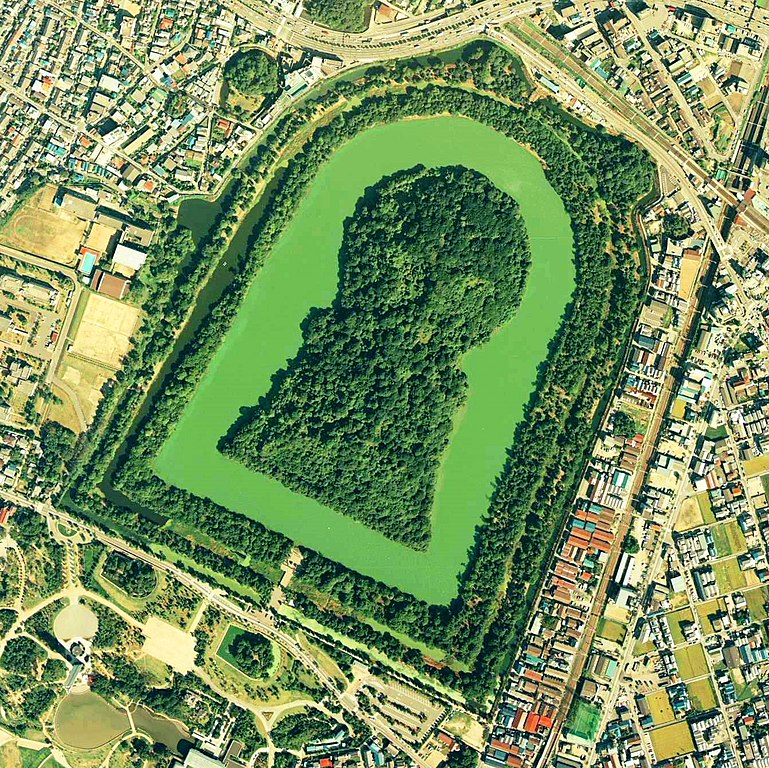
Daisen-kofun in Sakai, Osaka, Japan. This is one of the largest tombs in the world. Japanese government regards this as the tomb of Emperor Nintoku, the 16th emperor, but many historians don't think so. The keyhole-like tomb is 486m long, 305m wide at the bottom and 245m in diameter. English: Daisen-Kofun, the tomb of Emperor Nintoku, Osaka
Español: El Daisen-Kofun, tumba legendaria de Emperador Nintoku
Suomi: Kofun-kauden hautakumpu Osakassa, yksi maailman suurimmista. |
| Data | |
| Fonte | http://w3land.mlit.go.jp/cgi-bin/WebGIS2/WC_AirPhoto.cgi?IT=p&DT=n&PFN=CKK-85-2&PCN=C2&IDX=8 |
| Autore | Ministry of Land, Infrastructure and Transport Government of Japan & moja resized |
| Licenza (Riusare questo file) |
GFDL |
| Luogo dello scatto | | Posizione di questa e altre immagini su: OpenStreetMap |
|---|
- 仁徳天皇陵とされる古墳
- ソース
- 整理番号:CKK852-C2-8
- 撮影:1985年(昭和60年)

|
Il detentore del copyright di questo file, the Ministry of Land, Infrastructure, Transport and Tourism of Japan, permette a chiunque di utilizzarlo per qualsiasi scopo, a condizione che il detentore del copyright venga riconosciuto come tale. Sono consentiti la redistribuzione, le opere derivate, la modifica, l'uso commerciale ed ogni altro uso. |
Attribuzione:
Copyright © National Land Image Information (Color Aerial Photographs), Ministry of Land, Infrastructure, Transport and Tourism
|
 |
This image is copyrighted by the Ministry of Land, Infrastructure, Transport and Tourism of Japan. For terms of use, see the stipulation to use of National Land Information (in Japanese) and message from MLIT (in Japanese and English). When you display this image on an article, include the following phrase in the description: "Made based on National Land Image Information (Color Aerial Photographs), Ministry of Land, Infrastructure, Transport and Tourism".
|
Cronologia del file
Fare clic su un gruppo data/ora per vedere il file come si presentava nel momento indicato.
| Data/Ora | Miniatura | Dimensioni | Utente | Commento | |
|---|---|---|---|---|---|
| attuale | 11:19, 7 giu 2020 | | 1 345 × 1 344 (2,38 MB) | 名古屋太郎 | 明るさ等変更 |
| 22:44, 17 ago 2005 |  | 800 × 800 (515 KB) | Moja~commonswiki | {{Information| |Description=Daisen-kofun in Sakai, Osaka, Japan. This is one of the largest tombs in the world. Japanese gorvernment regards this as the tomb of Emperor Nintoku, the 16th emperor, but many historians doubt don't think so. The keyhole-lik |
Utilizzo del file
Nessuna pagina utilizza questo file.
Utilizzo globale del file
Anche i seguenti wiki usano questo file:
- Usato nelle seguenti pagine di en.wikipedia.org:
- Usato nelle seguenti pagine di fr.wikipedia.org:
- Usato nelle seguenti pagine di ja.wikipedia.org:
- Usato nelle seguenti pagine di www.wikidata.org:
- Usato nelle seguenti pagine di zh.wikipedia.org: